Large-Scale Multi-View 3D Reconstruction from Google Street-View Images

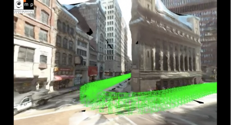
Get ready to be a part of the 3D map wars. While Google and Apple battle it out in creating complete 3D fully-textured models with their arsenal of impressive technological gadgetry, we could take part in our own personal skirmishes in generating 3D models of our own cities. Using sequential feature matching of images from street-view, generate 3D models through open-source image-based visualisation techniques. 

Michal Jancosek and his team from CMPMVS, a multi-view reconstruction software, experiments with large scale multi-view 3D reconstruction from Google Street-View Images. Fully automatic 3D reconstruction from 2424 600×800 images. Click here to view the video and go to http://ptak.felk.cvut.cz/sfmservice/ for more information.

Urban Network Analysis Toolbox for ArcGIS 10

The City Form Research Group at MIT has released a state-of-the-art toolbox for urban network analysis. It comes as ArcGIS 10 toolbox and can be used to compute five types of graph analysis measures on spatial networks: Reach; Gravity; Betweenness; Closeness; and Straightness. Due to a very tight time schedule this month, I had no time to test it yet but the Youtube video looks very promising and I would appreciate any reports from users.

Direct download link

Siggraph 2011 – Day 3

One of todays` highlights at SIGGRAPH 2011 in Vancouver was the approach of Prof. Deussen`s group in Konstanz and their partners at the universities in Shenzhen and Tel Aviv to use so-called “texture-lobes” for tree modelling from Lidar data. For more information, see http://graphics.uni-konstanz.de/publikationen/2011/texturelobesfortreemodeling/website/

Texture-Lobes for Tree Modelling from Soeren Pirk on Vimeo.

The afternoon was dedicated to urban modeling, starting with a review of the latest literature by Peter Wonka (Arizona State University) and Daniel Aliaga (Purdue University). During the second part of the session, Pascal Mueller from Procedural/ESRI (CityEngine) presented issues encountered in practice and their new Urban Vision project together with the urban planning department of San Francisco and Urban Sim (Paul Waddell). The session closed with a visually very engaging case study by Michael Frederickson from Pixar, using CityEngine for virtual London in Cars 2.

Bright (GIS) Future for CityEngine

On July 11, 2011, Esri has announced the acquisition of Procedural Inc, Zurich.

Years after the nifty but discontinued attempts of the SketchUp 6 / ArcGIS 9.2 Plug-in, ESRI takes the gloves off and finally makes a true jump into 3D cities modeling, planning and design. And finally GIS meets Games Design and vice versa. The rule-based approach of CityEngine apparently tasted right to Esri.
Read the press release.

Here are FAQs for CityEngine customers. Personally, I like the Question “Who is Esri and Jack Dangermond” the most. FYI, Procedural customers: Jack is one of the most interesting personalities I have met and he has a memory for faces and names of several petabytes.

I find it very interesting how Esri’s GeoDesign strategy and the CityEngine technology will merge.

Addendum: Esri Adds 3D Design Tools with Procedural Acquisition by Matt Ball

Play the CityOne Game

IBM has launched CityOne, a serious game that aims to raise awareness, and help address some of the challenges and solutions for building a smarter city.

CityEngine Vue

This blog has already reported about the landscape renderer Vue and about CityEngine, a tool by Swiss company Procedural Inc. that allows creating 3d city models from scratch. Now, there is a new product marrying both, CityEngine Vue.

Almost unnoticed: Bing Maps 3D is dead

I was trying to re-visit the SpeedTree trees in Bing Maps 3D, but strangely the 3D interface of Bing Maps has disappeared. Then I found  this announcement on Bing Maps Blog.

Many comments express their concerns about the discontinuation of the 3D control, SDK licensees seemed totally surprised that 3D control is discontinued without a replacement or replacement announcement. Has Mircosoft given up to compete with Google Earth?

Autodesk // Labs_ Project Galileo

Project Galileo will be previewed at Autodesk University, Dec 1st, 2010. Galileo is an easy-to-use planning tool for creating 3D city models from civil, geospatial and building data, and 3D models. Galileo also enables users to sketch conceptual infrastructure ideas within the 3D city model. Using Galileo, planners, GIS analysts, project managers, and architects can help stakeholders better understand infrastructure projects and plans in the context of the built and natural environment.

Check: http://atlandsend.typepad.com/at-lands-end/

Is it based on the LandXplorer framework?

Autodesk// Labs_ Project VASARI – Conceptual design and analysis for buildings

Download and check out this technology preview:
“Autodesk® Project Vasari is an easy-to-use, expressive design tool for creating building concepts. Vasari goes further, with integrated analysis for energy and carbon, providing design insight where the most important design decisions are made. And, when it’s time to move the design to production, simply bring your Vasari design data into the Autodesk® Revit® platform for BIM, ensuring clear execution of design intent.

Project Vasari is focused on conceptual building design using both geometric and parametric modeling. It supports performance-based design via integrated energy modeling and analysis features. This new technology preview is now available as a free download and trial on Autodesk Labs.”

Sounds like a sort of SketchUp with Add-ons for BIM and analysis. VASARI is based on the Revit framework but with a different GUI.

Stereo multi-touch tabletop interface

Immersion has developed as part of the EU’s V-City project, a collaborative tabletop interface to interact with 3d city environments. The prototype was shown at Siggraph 2010. The multi-view support allows two users to view different viewpoints of the model at the same time from the same 3d mockup.