Open Position: PhD Candidate in landscape planning

Screen Shot 2016-07-21 at 12.07.40


Open Position: PhD Candidate in landscape planning

The Chair of Planning of Landscape and Urban Systems at ETH Zürich has an opening in the area of GIS and remote sensing based landscape planning. The research group focuses on understanding how the interactions and/or actions of humans shape landscapes at various temporal and spatial scales. For fostering participatory landscape planning, they investigate how people perceive the landscape using state-of-the-art 3D visualizations of landscape changes and generate decision support tools. Particularly, they explore how an iterative process between design and science can allow co-creating place specific responses satisfying human needs and demands for well-being in a sustainable manner.

In the frame of the module “Ecosystem Services in Urban Landscapes” at the Future Cities Laboratory (FCL) in Singapore, a joint initiative between the Swiss Federal Institute of Technology Zurich (ETH Zurich) and Singapore’s National Research Foundation, we are looking for

a doctoral student (100%) in landscape planning

to build a ecosystem services-based decision support system for planning urban green areas in mega-cities.
For setting up such a spatially explicit decision support system, we are looking for a highly skilled and motivated candidate to work on the development of ecosystem services modeling approaches using as far as possible earth observation data in an urban environment. Ground truthing will be done in cooperation with ecologists.
The candidate should have a Master’s degree in environmental sciences, ecology, geography, or applied geoinformatics with expertise in ecosystem science, remote sensing, natural resources management, and geospatial analysis. Skills in English scientific writing within the subject area will be given emphasis in the evaluation. Furthermore, strong communication, interpersonal and teamwork skills are needed, as there will be a strong collaboration with landscape architects, landscape ecologists, and water engineers in the frame of the project. The workplace will be at the Future Cities Lab in Singapore, a vibrant and highly innovative setting. The PhD will obtained from ETH Zurich.
For further information, please contact gret@ethz.ch (no applications) or visit our website at http://www.fcl.ethz.ch/module/ecosystem-services-in-urban-landscapes/ and www.plus.ethz.ch

Please submit your application online (Apply now), which includes a comprehensive CV, cover letter, diplomas, work certificates, and contact information of at least two references and upload all documents (pdf is recommended) to ETH Zurich, Mrs. Corina Niescher, Human Resources, CH-8092 Zurich. The position will remain open until filled.
Fully funded PhD on landscape visualization at the University of Rhode Island

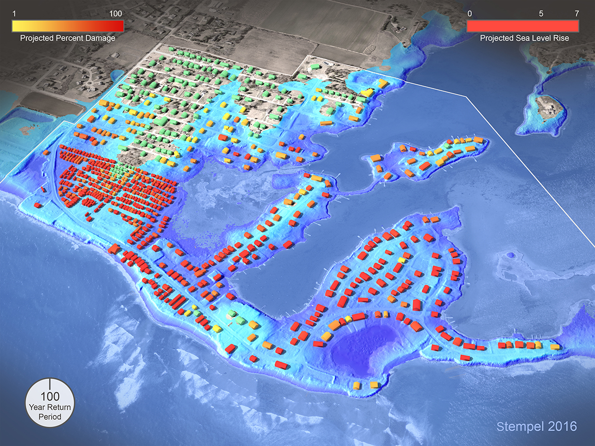
(c) Peter Stempel (2016)

In his dissertation, Peter Stempel at the University of Rhode Island has done outstanding research about the ways in which realism used in visualizations influences the perception of risk (see the figure above for an example). His particular focus has been on storm surges and sea level rise, continuing some of the work done by Prof. Stephen Sheppard, David Flanders, me and others at the Collaborative for Advanced Landscape Planning at UBC and published in Sheppard (2012) “Visualizing Climate Change”.

(c) Peter Stempel 2016

Peter has also made a short presentation at a recent estuarine and coastal modelling conference last week and you can watch a narrated version here: https://vimeo.com/171324965

Now, the University has created a position for someone to participate in and continue the work Peter has begun. This position is a fully funded assistantship focused on visualization (PhD).  Rhode Island University are actively recruiting applicants.

Contact regarding the PhD position should go to Dr. Austin Becker abecker@uri.edu, and Dr. Peter Stempel peter_stempel@uri.edu.

PhD candidate job description


Save

Save

Save

Postdoctorand in Geospatial Visualisierung

Das Leibniz-Institut für Länderkunde (IfL) in Leipzig sucht zum 1. September 2016 eine(n)

Postdoctorand in Geospatial Visualisierung

(1,0 TV-LE13, befristet bis zu vier Jahren)

zur Mitarbeit in bestehenden Forschungsprojekten und zur Entwicklung neuer Visualisierungs- möglichkeiten im Rahmen von digitalen und gedruckten Atlanten und weiteren Institutspublikationen des IfL. Die Mitarbeit unter­stützt Forschungs- und Transferprojekte, die Ansätze der Geographie, Informationswissenschaften, Com­puter­wissen­schaften und Kartographie verknüpfen. Bevorzugt werden Kandidaten mit Forschungsinteressen in inno­va­tiven Formen der Raum-Zeit-Visualisierung, kulturellen Dimensionen der Visualisierung und Geovisualisierung mit neuen Medien.

Die vollständige Stellenausschreibung finden Sie unter www.ifl-leipzig.de/de/aktuell/Stellenangebote.html


PhD scholarship in 3D visualization technology and environmental perceptions in landscape and urban design at NMBU – Ref.no 16/01199

The Department of Landscape Architecture and Spatial Planning (ILP) at the Norwegian University of Life Sciences (NMBU) is announcing a 3 year PhD fellowship position for a qualified candidate in the topic: “The role of 3D visualization technology in testing environmental perceptions in the context of landscape design and urban planning processes”. 3D and visualization methods have yet to harness their full potential as research methods for testing the reactions and perceptions of users to particular environmental conditions and qualities that favour livability in various urban design contexts. Much environmental psychology research occurs either in the field, through audits and site observations, or in a laboratory, relying mainly on pictures or other static forms of landscape representations. 3D technology has yet to be used to bridge the gap between laboratory and real-life experience, and would allow us to collect data across a variety of geographical contexts, and without the need for expensive site visits for all subjects.

This PhD project would strengthen research on digital applications in landscape architecture and urban planning. The aim is to explore the potentials and challenges associated with 3D digital tools and visualizations when applied in the areas of urban design, urban systems planning, landscape design. The research will make use of a collaborative research environment at ILP by cooperating with other researchers and sections. In addition, the VR-Lab will be used as arena to facilitate the research work experimentation with new technologies in sharing knowledge, increasing interdisciplinary collaboration, and engaging users.

https://www.jobbnorge.no/ledige-stillinger/stilling/123304/phd-scholarship-in-3d-visualization-technology-and-environmental-perceptions-in-landscape-and-urban-design-refno-16-01199

Postdoctorate Position in Geospatial Visualisation

The Leibniz Institute for Regional Geography (IfL) in Leipzig invites applications from highly qualified and motivated individuals for a

Postdoctorate Position in Geospatial Visualisation
(full-time, salary based on TV-L13,
for a period of four years)

to begin on 1 January 2016 on work on current research projects, develop new possibilities of visualisation in digital atlases, create other visualisations and contribute to maps for publications of the IfL.

The complete job advertisement is available online at: www.ifl-leipzig.de/en/news/jobvacancies.

You can find further information about the Leibniz-Gemeinschaft
at www.leibniz-gemeinschaft.de

Master program in Visualization at Texas A&M University

The Department of Visualization at Texas A&M University mailed me the following call for applications as Master students. The program sounds very interesting to me and I would like to share it here with you:

"We are seeking qualified applicants for our well-regarded thesis-based Master of Science and our unique technology infused Master of Fine Arts programs in Visualization.

Twenty years after its founding, former students of our graduate Visualization program now constitute one of the largest groups in the animation, special effects and game industries. More than 200 of our former students are currently working in the animation and special effects industry, including PIXAR, ILM, DreamWorks, Electronic Arts, Blue Sky and Rhythm & Hues Studios.
 
If you know of students who have a strong interest in pursuing graduate work in the intersection of the artistic, scientific, and technical aspects of visualization, including fine art, electronic and digital media, and computer animation, please direct them to our website: http://www.viz.tamu.edu. For full scholarship consideration, the early application deadline for Fall 2013 is December 15. The final application deadline is January 5."

Terrain Modelling in Digital Landscape Design

This web portal on terrain modelling has been created at Forest and Landscape, University of Copenhagen by landscape architects José Lameiras and Ian Jørgensen. Both have a background teaching IT in landscape architecture. Focus is on digital technologies to interact with surface models and develop landscape design. So, this is about LIM – Landscape Information Modelling as a response to architect’s BIM (Building IM).

http://www.novaland.dk/neo/

Job opening at the Macaulay Institute Aberdeen

The Macaulay Institute in Aberdeen is currently seeking a landscape and visualisation modeller and a spatial planner. For further information, please refer to
http://www.macaulay.ac.uk/jobs/