
The new release of the free Landscape Scenery Globe Biosphere3D adds rendering effects such as ambient occlusion, shadow mapping and creation of camera paths and capture of animations.

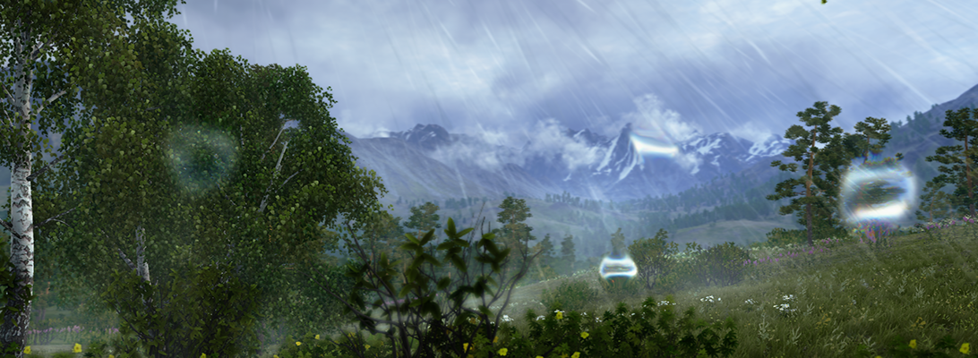
The new release of the free Landscape Scenery Globe Biosphere3D adds rendering effects such as ambient occlusion, shadow mapping and creation of camera paths and capture of animations.

Funded by the Swiss National Science Foundation SNSF, and in collaboration with the Collaborative for Advanced Landscape Planning (CALP), particularly Ellen Pond, the City of Kimberley, and the Columbia Basin Trust (CBT), I analysed the benefits and limitations of interactive virtual globes for stakeholder engagement in climate related scenario planning over the last 12 months. The results have now been published as SNSF report and can be downloaded here.
Microsoft Photosynth is a photogrammetric software that creates 3d buildings from multiple photos, e.g. shot by random tourists. Our colleagues from the urbandigital blog are very much in favour of Photosynth and see great potential in it for urban visualization or as a kind of 3d scanner. Now, Microsoft has taken the logic next step and integrated Photosynth with Bing 3D. It may be criticized that the Microsoft approach requires Silverlight which is still not standard. However, Bing users can now create buildings automatically from photos whereas Google Earth users are modeling their content in Sketchup. It will be very interesting to test both approaches in comparison and to see which one will finally find more users.
Another interesting approach by Microsoft is mentioned by Chris Dannen in the Fast Company blog: In the long-term, Microsoft wants to extract semantic information automatically from the user-generated photos. In this point, Microsoft meets latest research in photogrammetry, e.g. in the “Nachwuchsgruppe der Volkswagen Stiftung” in cartography at the University of Hanover, where the automatic extraction of facades from photos is researched.
With regard to landscapes, vegetation is still not an issue – neither for Google nor for Microsoft. How about the automatic extraction of vegetation information from photos? There is a lot research about the recognition of vegetation in orthophotos – how about linking this to the automatic population of virtual landscapes with realistic plants?
Biosphere3D is now available at Sourceforge:

ESRI has released a new version of its digital globe “ArcGIS Explorer”. The new version provides an improved interface; enhanced data support including kml/kmz; the opportunity to switch between 2D and 3D; a new presentation mode with titles, pop-ups, layers etc.; new online data libraries; a SDK for customization and plenty of projections to choose from. With the online data, there is also a direct link to BING maps and if some of you remember my previous article on the co-operation between Microsoft and ESRI, this is probably one of its first outcomes.
In the times of GoogleEarth, where is the niche for ArcGIS Explorer? Well, there are some good reasons, why ArcGIS Explorer might be worth a consideration for landscape planners: First, most of us are already working with ArcGIS and the workflow is easier than it is between ArcGIS and GoogleEarth, where you need CommunityViz or other plugins. Particularly, you can add plenty of geodata formats and your own DEM which is not possible in GoogleEarth. Then, the presentation mode is neat for planners who present to the public. And finally, the possibilities to choose a specific projection or even to customize your interface may meet expert needs that GoogleEarth cannot satisfy.
41TB of new imagery, vector data etc… The following URL will start a tour through some of the updated locations: http://bingmapsupdates.cloudapp.net
Biomass in Future Landscapes from Philip Paar on Vimeo.
Fly-throughs are quite popular, especially since the success of Google Earth but what matters more to landscape perception is the human perspective from eye-level view. Lenné3D, a Berlin based corporation, has been invited by the German Biomass Research Centre (DBFZ) to create this visual stunning simulation of future cultural landscape scenarios by virtually implementing biomass into an existing landscape. Our contribution tries to advance the paradigm of Humphrey Repton’s famous before-and-after landscape depictions with dynamic navigation, and to trigger fruitful discussions on the various aspects and issues of biomass in cultural landscapes.
The video animation “Biomass in Future Landscapes” shows both fly-through and walk-troughs and a time travel. New landscape scenery patterns and time and again views arise from implementation of linear structures such as alley-cropping systems.
The video is based on a virtual 3D model derived from geodata such as a digital elevation model and land use maps and field patterns, vegetation relevés, and descriptions of cropping practices. A plant distributor software arranges the vegetation cover. Finally, a virtual camera flies and walks though the 3D landscape model and the animation is rendered using the interactive Lenné3D-Player software.
The video was presented first at the international conference Biomass in Future Landscape, Berlin, March 31st – April 1st 2009.

In their latest preview of ArcGIS 9.3.1, ESRI announced their intensified partnership with Microsoft, marrying ArcGIS with VirtualEarth.As we currently test in a series of planning workshops in the Rockies, the combination of GIS for spatial analysis and Virtual Globes for visualization and communication is very powerful. In the near future, I will tell you more about the workflow ArcGIS -> CommunityViz -> GoogleEarth / Biosphere3D, including some first screenshots.
For the forthcoming ArcGIS-VirtualEarth integration, please read the following ESRI press release (source: http://www.esri.com/software/arcgis/arcgisonline/whats_new.html).
ArcGIS Online 9.3.1 gives users quick and easy access to a set of foundation services for GIS projects, and provides a platform to discover and share geographic information.
A new agreement between ESRI and Microsoft gives ArcGIS users seamless access to Virtual Earth services. ArcGIS Desktop, ArcGIS Server, and ArcGIS Explorer users will be able to directly connect to Virtual Earth services to enhance their GIS projects.
With ArcGIS Online, users can
Better sharing of layers
More information can be found in the VirtualEarth Evangelist Blog (no guarantee for the objectivity or correctness for links to third-party blogs)
The new version of GoogleEarth, which can be downloaded now, has been extended by the underwater landscape of the Earth – which is two third of the Earth’s surface… Furthermore, the function for setting up your own tours has been improved and the time-travel function has become standard. Now, it will be really interesting to use GoogleEarth to show landscape development over time, historic and into the future. Oh, and finally, they added the Mars. For a more detailed summary of the new functions in German, see the Der Google Produkt-Kompass: Reise unter die Meeresoberfläche mit Google Earth 5.0 or Youtube (English):