If you can’t see the tree layer and your Google Earth user interface is other than English, change the language to US English and the Trees show up in the 3D buildings options http://earth.google.com/support/bin/static.py?page=guide.cs&guide=22358&topic=22360&answer=148181
commercial
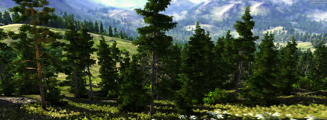
Review of GE 3D Trees
I have been expecting 3D trees in Google Earth for years. I am just surprised that the 3D trees look relatively ugly (1990ies computer graphics). But it is indeed a step towards landscape visualization.
In fall 2008, Microsoft’s globe formally known as “Virtual Earth” got some nicer 3D trees from SpeedTree. But they only included a few cities such as parts of Miami.
Paar and Clasen (2007) describe a landscape scenery globe focusing on complex 3D vegetation cover, including shrub, grass and herb layers.
Currently, in GE 6, there are some misplaced trees (not there in reality or placed in the middle of roads). I am wondering when Google will add tools to SketchUp and GE for planting trees. Then I guess users will ask how to distribute larger areas of plants. This is was ArcGIS users and Biosphere3D users have always been asking us.
Autodesk // Labs_ Project Galileo
Project Galileo will be previewed at Autodesk University, Dec 1st, 2010. Galileo is an easy-to-use planning tool for creating 3D city models from civil, geospatial and building data, and 3D models. Galileo also enables users to sketch conceptual infrastructure ideas within the 3D city model. Using Galileo, planners, GIS analysts, project managers, and architects can help stakeholders better understand infrastructure projects and plans in the context of the built and natural environment.
Check: http://atlandsend.typepad.com/at-lands-end/
Is it based on the LandXplorer framework?
Autodesk// Labs_ Project VASARI – Conceptual design and analysis for buildings
Download and check out this technology preview:
“Autodesk® Project Vasari is an easy-to-use, expressive design tool for creating building concepts. Vasari goes further, with integrated analysis for energy and carbon, providing design insight where the most important design decisions are made. And, when it’s time to move the design to production, simply bring your Vasari design data into the Autodesk® Revit® platform for BIM, ensuring clear execution of design intent.
Project Vasari is focused on conceptual building design using both geometric and parametric modeling. It supports performance-based design via integrated energy modeling and analysis features. This new technology preview is now available as a free download and trial on Autodesk Labs.”
Sounds like a sort of SketchUp with Add-ons for BIM and analysis. VASARI is based on the Revit framework but with a different GUI.
ESRI ArcGIS + Procedural CityEngine + Nvidia RealityServer
Procedural has joined ESRI’s Business Partner Program. Automatic creation and cloud-based visualization of photorealistic 3D cities from ArcGIS data with CityEngine and RealityServer. Presented on a Tegra Tablet at ESRI User Conference 2010 in San Diego.
Bing Maps incorporates Photosynth models and is aiming at semantics in the long-term
Microsoft Photosynth is a photogrammetric software that creates 3d buildings from multiple photos, e.g. shot by random tourists. Our colleagues from the urbandigital blog are very much in favour of Photosynth and see great potential in it for urban visualization or as a kind of 3d scanner. Now, Microsoft has taken the logic next step and integrated Photosynth with Bing 3D. It may be criticized that the Microsoft approach requires Silverlight which is still not standard. However, Bing users can now create buildings automatically from photos whereas Google Earth users are modeling their content in Sketchup. It will be very interesting to test both approaches in comparison and to see which one will finally find more users.
Another interesting approach by Microsoft is mentioned by Chris Dannen in the Fast Company blog: In the long-term, Microsoft wants to extract semantic information automatically from the user-generated photos. In this point, Microsoft meets latest research in photogrammetry, e.g. in the “Nachwuchsgruppe der Volkswagen Stiftung” in cartography at the University of Hanover, where the automatic extraction of facades from photos is researched.
With regard to landscapes, vegetation is still not an issue – neither for Google nor for Microsoft. How about the automatic extraction of vegetation information from photos? There is a lot research about the recognition of vegetation in orthophotos – how about linking this to the automatic population of virtual landscapes with realistic plants?
ArcGIS Explorer

ESRI has released a new version of its digital globe “ArcGIS Explorer”. The new version provides an improved interface; enhanced data support including kml/kmz; the opportunity to switch between 2D and 3D; a new presentation mode with titles, pop-ups, layers etc.; new online data libraries; a SDK for customization and plenty of projections to choose from. With the online data, there is also a direct link to BING maps and if some of you remember my previous article on the co-operation between Microsoft and ESRI, this is probably one of its first outcomes.
In the times of GoogleEarth, where is the niche for ArcGIS Explorer? Well, there are some good reasons, why ArcGIS Explorer might be worth a consideration for landscape planners: First, most of us are already working with ArcGIS and the workflow is easier than it is between ArcGIS and GoogleEarth, where you need CommunityViz or other plugins. Particularly, you can add plenty of geodata formats and your own DEM which is not possible in GoogleEarth. Then, the presentation mode is neat for planners who present to the public. And finally, the possibilities to choose a specific projection or even to customize your interface may meet expert needs that GoogleEarth cannot satisfy.
Major Bing Maps Update
41TB of new imagery, vector data etc… The following URL will start a tour through some of the updated locations: http://bingmapsupdates.cloudapp.net
Siggraph 2009
Currently, SIGGRAPH 2009 takes place and many visualization companies show their latest product versions. Autodesk focussed mainly on Maya, no news from LandXplorer here. However, they are currently working on a complete re-programming of the promising geobrowser, so that might still take a while.
Always interesting for landscape visualization is E-on’s software Vue (see the previous post on Vue 7) which will be released as Vue 8 until the end of the year. The new version will support 3D terrain modelling and even more advanced atmospheric models for haze and clouds. The image shows a recent test rendering in Cinema 11 with trees, wave and atmosphere model from the Vue 7 plugin for Cinema.

ArcGIS 9.3.1: Partnership between ESRI and Microsoft

In their latest preview of ArcGIS 9.3.1, ESRI announced their intensified partnership with Microsoft, marrying ArcGIS with VirtualEarth.As we currently test in a series of planning workshops in the Rockies, the combination of GIS for spatial analysis and Virtual Globes for visualization and communication is very powerful. In the near future, I will tell you more about the workflow ArcGIS -> CommunityViz -> GoogleEarth / Biosphere3D, including some first screenshots.
For the forthcoming ArcGIS-VirtualEarth integration, please read the following ESRI press release (source: http://www.esri.com/software/arcgis/arcgisonline/whats_new.html).
What’s New in ArcGIS Online 9.3.1
ArcGIS Online 9.3.1 gives users quick and easy access to a set of foundation services for GIS projects, and provides a platform to discover and share geographic information.
Virtual Earth Now Seamlessly Integrated with ArcGIS
A new agreement between ESRI and Microsoft gives ArcGIS users seamless access to Virtual Earth services. ArcGIS Desktop, ArcGIS Server, and ArcGIS Explorer users will be able to directly connect to Virtual Earth services to enhance their GIS projects.
- ArcGIS Desktop
- Free, limited annual allotment for users who are current on maintenance
- Annual subscription with unlimited transactions available for purchase
- ArcGIS Explorer
- Access Virtual Earth and share transactions as part of an existing ArcGIS Desktop license.
- ArcGIS Explorer users who do not have an ArcGIS Desktop license, can evaluate Virtual Earth at no cost for 90 days.
- Annual subscription with no transaction limits is available for purchase.
- ArcGIS Server
- Built-in 90-day evaluation of Virtual Earth, after which an annual, transaction-based subscription can be purchased
New Location Services
- World geocoding (available for use with ArcGIS 9.3)
- Geocoding, batch geocoding, reverse geocoding for North America and Europe
- World place finding (countries, provinces, cities, landmarks)
- Routing
- Point-to-point and optimized routing for North America and Europe
- Drive Time
- Calculate drive-time polygon using an input location and drive-time values.
Discover and Share Geographic Information
With ArcGIS Online, users can
- Search for maps published by ESRI and other users.
- Upload maps and register online map services.
- Organize and control access to shared maps.
- Save Web maps as items for others to share, discover, and use.
Better sharing of layers
- Layers referencing feature or raster data can be combined into a single layer package that comprises of both the layer file and data.
- These layer packages can be shared with other users via the new ArcGIS Online sharing capability, through files, or by e-mail.
More information can be found in the VirtualEarth Evangelist Blog (no guarantee for the objectivity or correctness for links to third-party blogs)