Future is all change with digital technology

As part of the Landscape Futures lecture series, organised by the Landscape Institute, digital technologies were the topic in March. From the press release:

“Digital technology is altering all aspects of landscape, according to speakers at the most recent Landscape Futures debate, ‘How will the digital future affect the urban landscape?. It is affecting the way that landscape architects design, the way that they gather information and the way that people use the landscape.

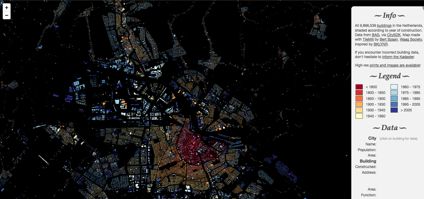
Sophie Thompson, a director of LDA Design and the main speaker, talked about intelligent space mapping. Information gathered from smartphones for example can be used to understand better how people actually use cities. Projects such as Dublinked make vast amounts of data available for sharing.

Is this valuable for analysis, Thompson asked, or is it information overload? ‘It should enable us to understand more accurately how people perceive, use and move through the public realm and about the environment generally,’ she said. ‘As time goes on these datasets will become more accessible and easy to understand and also the different data sets are starting to be aggregated.’

Read the full article on the Landscape Institute website.

“See the Change” – Article in Landscape Architecture Magazine December 2013 about Climate Change Visioning

On pages 64ff. of its December issue, the Landscape Architecture Magazine LAM is reporting about the Climate Change Visioning work at the Collaborative for Advanced Landscape Planning:

New paper about the use of interactive web tools in environmental and landscape planning (open access)

Sebastian Krätzig and Bartlett Warren-Kretzschmar
Article: Using Interactive Web Tools in Environmental Planning to Improve Communication about Sustainable Development
Sustainability 2014, 6(1), 236-250; doi:10.3390/su6010236
http://www.mdpi.com/2071-1050/6/1/236/

Today’s TED blog: Greg Asner about ecology from the air

Asner is giving various examples for the use of aerial photos and laser scanning data (LiDAR) in ecology, e.g. about the hunting behavior of lions, mapping the loss of forest, airborne taxonomic mapping, carbon mapping and many more. For a text version, please see http://blog.ted.com/2013/11/19/birds-eye-science-what-were-learning-about-the-planet-using-aerial-technology/

Piet Oudolf lecture at University of Sheffield, October 24 2013

Piet Oudolf, the world renowned planting designer has been appointed Visiting Professor of Planting Design at the Department of Landscape, at the University of Sheffield. Piet started his Professorship with a public lecture on Wednesday 23rd October 2013 at the University of Sheffield, showing some of his past and current projects (e.g. the Millennium Park in Chicago or the High Line in New York):


New blog on the blogroll: under the raedar

To begin with, I should say that I had less time to spend on the LVIZ blog since I moved on to a new position as lecturer in landscape planning and GIS at the University of Sheffield. Said that, my move to the UK also comes with meeting new researchers who do exiting work around GIS and landscape. One of these researchers is Alasdair Rae and his blog “under the raedar”. The focus is on geospatial data and all the amazing things you can do with it: http://undertheraedar.blogspot.co.uk/

In this context, I would also like to draw your attention to an amazing Dutch website that he pointed out in his lecture. http://dev.citysdk.waag.org/buildings/ is an interactive map of ALL 9.8 Mio. buildings in the Netherlands, color coded by year of construction.

Buildings in the Netherlands

Geodesign – Maximizing Beneficial Impacts International Conference, Bejing 28-29th October 2013

The following call for papers may be particularly interesting for our readers in China, especially in Beijing: The first international geodesign conference in Beijing will be held on October 28,29 2013. See the call for papers at www.geodesignpku.org

"This conference will be joint effort of the Peking University and ESRI. This International Geodesign Conference builds upon recent advances in the US and elsewhere, in bringing together a combination of experts – planners, designers, scientists, public policy experts and decision makers – to present and discuss current projects, emerging models of Geodesign practice, and to speculate on directions and improvements for the future."

Please note that 30 April, 2013 is the deadline for submission of abstracts.

Le:Notre Online Seminar Landscape Architecture + Climate Change

Today, the University of Nuertingen hosts another session in its series of online lectures on landscape architecture and climate change. I invite you to join an interesting session scheduled for tomorrow, Tuesday, 8th of January, from 18 – 19 30 pm CET. You can join the seminar simply by clicking on this link and adding a guest name:

https://webconf.vc.dfn.de/onlineseminar/

Invited are three experts who have also published two books on the theme during the last year. The programme will be as follows:
 

  • Don Quixote, Sancho Panza and the Landscape Architect: Exploring Alternative Energy Landscapes, Dr. Sven Stremke|WUR Wageningen, NL
  • The social acceptability of energy landscapes, Dr Olaf Schroth
  • Engaging Communities on Climate Change with Visual Learning Tools, Stephen Sheppard, UBC Pacific Institute for Climate Solutions

We will end the session with an interactive discussion.

In the coming weeks there will be two further sessions – the last of this series –  that might be of interest for you. They are accessible the same way as this one, always from 18 – 19 30 CET:

  • Tuesday, 15th of January: Adapting open space planning to climate change Lecture by Dr. Sanda Lenzholzer|WUR Wageningen, NL
  • Tuesday, 22nd of January: Adapting Urban Planting design to climate change Lecture by Dr. MaryCarol Hunter|University of Michigan, USA

Please note that the presentations are further provided online under the following URL where you can watch them even if you miss the live discussion:

http://fluswikien.hfwu.de/index.php/Course_Schedule_Seminar_Climate_Change_2012


Interactive Modeling of Self-Adapting Botanical Trees

Already a few weeks ago, a colleague drew my attention to a couple of new papers on interactive self-adapting botanical tree models, published by the computer visualization group in Konstanz, who had also presented at Siggraph 2011 (see my previous post about Siggraph). This new development in procedural modeling techniques makes tree models possible that will interact with their environment! For example, if you insert a building, the surrounding trees will change their shape and branches will give way to the new object in a most realistic way.

How are these astonishing results achieved? Input is a skeleton-based tree geometry. In contrast to traditional tree growing models, the new technique approximates biologically motivated transformations. Main factor is the light distribution and the amount of resources a tree receives. On that basis, the growth rate for the entire tree and individual branches as well as branch ages are calculated. A complex illumination model makes sure that light conditions are updated for different stages of tree growth. Additional factors are phototropism and gravitropism and I was surprised how realistic the outcomes look.

Because the approach does not require the tree model to be reconstructed from the beginning, it performs much better than previous approaches and is even suitable for real-time applications. That means, you could insert an object such as a building but also other trees and experiment in real-time how the surrounding trees might change their growth in response to each other and inanimate objects.

For more information and the original research paper, please see

SIGGRAPH 2012:
http://graphics.uni-konstanz.de/publikationen/2012/plastic_trees/website/

SIGGRAPH Asia 2012:
http://graphics.uni-konstanz.de/publikationen/2012/tree_growth/website/

Plastic Trees: Interactive Modeling of Self-Adapting Botanical Trees from Soeren Pirk on Vimeo.


Call for Papers: CORP 2013 Rome

PLANNING TIMES

You better keep planning or you get in deep water,
for the cities they are a-changin' …

The REAL CORP Call for Papers is open until 23 December 2012. We accept papers in two categories:

  • Reviewed Papers: scientific papers which undergo a two-step peer review (up to 10 pages);
  • Non-Reviewed Papers: practical experience reports, project reports: decision on acceptance is made by programme committee (up to 5 pages).

The reviewing procedure is an important tool in enhancing the paper quality and therefore the expert output in general of the REAL CORP conference. Papers will not only be evaluated on scientific quality but also with focus on pratical relevance and “visionary approaches”. The group of reviewing experts comprises of researchers, practitioners and business experts. There is also the opportunity to register papers for non-reviewed participation. In this case, members of the organising REAL CORP team will decide on paper acceptance.

Detailed Information for authors


Topics of REAL CORP 2013

Click here for a detailed overview on all major topics and sub topics of REAL CORP 2013.


How to submit your abstract

Abstract submission may only be done electronically. Please download our template before you compose your abstract:

To upload your abstract to our server, please sign up for a user account on our conference administration portal MY.CORP. The abstract should not exceed 1 page in the given template and need not contain any graphics.


Deadline…

Of course, there is a deadline for abstract submission to make sure that both reviewers and programme committee have enough time so decide carefully on acceptance of each abstract.

Please submit your abstract by 23 December 2012, 23:59 CET. For submission you are intended to use MY.CORP only.

Further important deadlines on the way to having your paper published