Terrapattern: Visual search tool for satellite imagery

Terrapattern is an amazing research project originated at the University of Pittsburgh providing a visual search tools for the analysis of satellite imagery. Until now, such tools have only been accessible to intelligence services.
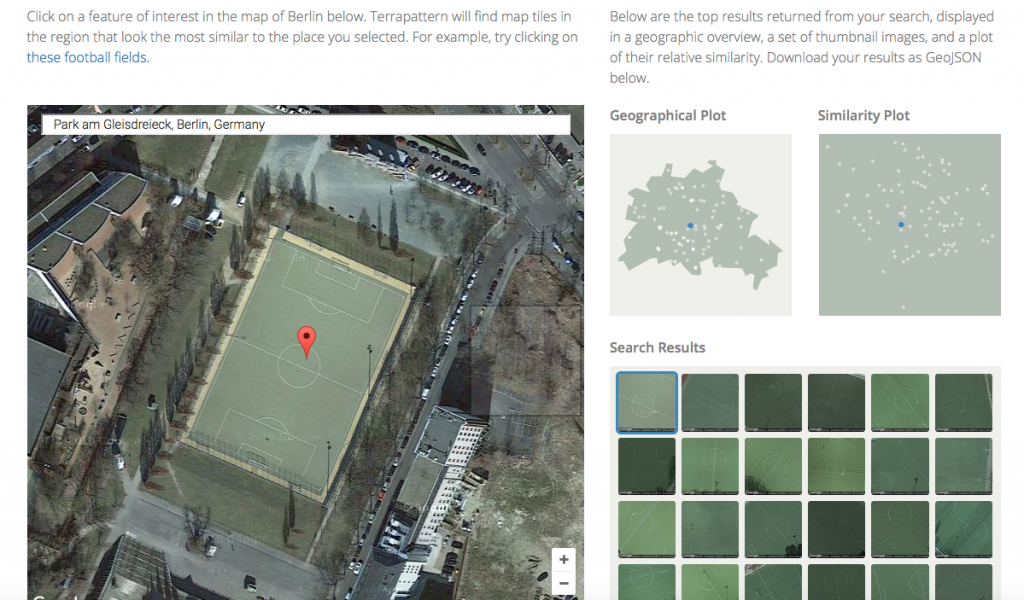
Terrapattern: Case study Berlin
Terrapattern: Football pitches in the Berlin case study

The search engine behind Terrapattern is based on an Artificial Intelligence (AI) and will learn, i.e.g improve, over time. You can for example select a church and then, Terrapattern will show all visually similar objects. For now, Terrapattern is only available for selected case studies, ie. Pittsburgh, San Francisco, New York, Detroit, Miami and Berlin!

Apart from the various commercial uses for such a visual search tool, I am excited about the potential for landscape studies. At the tip of a mouse click, Terrapattern will produce a typology of open space forms. You could search for playgrounds, cemetries or specific vegetation patterns! As soon as the tool is available outside of a few selected cities, it could also be used to describe different landscape types, e.g. in landscape character assessment, and make distinct landscape patterns visible.

Future Internet, Special Issue Landscape

The Open Access journal Future Internet  has just published interesting papers from LVIZ authors Olaf Schroth et al. and Philip Paar (with Jörg Rekittke):

Tool or Toy? Virtual Globes in Landscape Planning

Low-Cost Mapping and Publishing Methods for Landscape Architectural Analysis and Design in Slum-Upgrading Projects

Google Earth Outreach launches new tools for NGOs in Canada

Google Earth Outreach launched a program to support Canadian NGOs with software tools and support in a three-day workshop with the Tides Foundation in Vancouver, September 25-28, 2011. The workshop ended with a public event at the Woodwards featuring presentations by Rebecca Moore from Google Earth Outreach and David Suzuki.

Google Earth Outreach Launch Canada (Tides 2011)

The workshop aimed at capacity-building for NGOs and included sessions on Google Fusion Tables, Google mapping API, GIS to Google Earth basics, Advanced KML coding and and the Open Data Kit, a set of tools for mobile data collection. The Google Earth Outreach team also provided some first insights into the new Google Earth Builder, an online GIS for geodata management with tiling capabilities, and Google Earth Engine, a future environmental monitoring platform that adds more complex analytical functions such as GHG calculations.

More than 50 representatives from various NGOs participated and I was very impressed by their projects they presented after just three days: A complete Google Earth inventory of the Mountain Pine Beetle damage in British-Columbia, the  cinematic fly-through of a crane in GoogleEarth illustrating bird migration routes, and many more. Therefore, I am confident that the workshop achieved its first goal which was capacity-building among NGOs. The workshop site also provides many valuable tutorials on Google’s geospatial tools and is open to everybody.

Google Mapping Technology for Nonprofits

What: Google Mapping Technology for Nonprofits

When: September 26-28, 2011, 8:30am – 5:00pm

Where: Morris J Wosk Centre for Public Dialogue at Simon Fraser University, Vancouver, British Columbia

Who should attend?: This workshop is intended for Canadian nonprofit technology specialists.

More information: http://vancouver.earthoutreach.org/home

Redwood Watch

The following YouTube video shows Redwood forests in California and asks questions on how climate change may impact their future habitats. The Save the Redwoods League calls viewers for participating in mapping Redwood stands and thereby, contributing to the research about climate change impact on this species.

Mangroves of Mexico as Google Earth Outreach example for GE6 in cooperation with CONABIO

Three weeks ago, Google had launched its new version 6 of Google Earth parallel to the Cancun conference, where Google Earth Outreach participated as well. Now, Google Earth Outreach together with the Mexican National Commission for Knowledge and Use of Biodiversity CONABIO launched the first outreach project taking advantage of the newly implemented tree representations (download the kmz into GE here). The trees still look a bit sketchy in comparison to other products but the visualization seems to be based on credible and sophisticated vegetation data.

Source: Google Earth Outreach

Almost unnoticed: Bing Maps 3D is dead

I was trying to re-visit the SpeedTree trees in Bing Maps 3D, but strangely the 3D interface of Bing Maps has disappeared. Then I found  this announcement on Bing Maps Blog.

Many comments express their concerns about the discontinuation of the 3D control, SDK licensees seemed totally surprised that 3D control is discontinued without a replacement or replacement announcement. Has Mircosoft given up to compete with Google Earth?

3D Trees in GE, it is a feature not a bug

If you can’t see the tree layer and your Google Earth user interface is other than English, change the language to US English and the Trees show up in the 3D buildings options http://earth.google.com/support/bin/static.py?page=guide.cs&guide=22358&topic=22360&answer=148181

Review of GE 3D Trees

I have been expecting 3D trees in Google Earth for years. I am just surprised that the 3D trees look relatively ugly (1990ies computer graphics). But it is indeed a step towards landscape visualization.
In fall 2008, Microsoft’s globe formally known as “Virtual Earth” got some nicer 3D trees from SpeedTree. But they only included a few cities such as parts of Miami.
Paar and Clasen (2007) describe a landscape scenery globe focusing on complex 3D vegetation cover, including shrub, grass and herb layers.
Currently, in GE 6, there are some misplaced trees (not  there in reality or placed in the middle of roads). I am wondering when Google will add tools to SketchUp and GE  for planting trees. Then I guess users will ask how to distribute larger areas of plants. This is was ArcGIS users and Biosphere3D users have always been asking us.

GoogleEarth 6 plants 3D trees

Google published version 6 of GoogleEarth and the most important update for our profession is that it comes with 3D trees!

However, not the whole Earth is populated with trees yet but only some areas in a few selected cities: According to TechCrunch 80 million trees were “planted” in Athens, Berlin, Chicago, New York City, San Francisco and Tokyo. Yet, the quality of trees is rather low but Google claims to distinguish 50 species already. Other updates of version 6 include an enhanced integration of StreetView and a more user-friendly overview and navigation through historic aerial images. The new version is a beta and does not update automatically but must be installed from the Google download site. A GoogleEarth showcase can be downloaded here.

The key question for us is how the integration may facilitate the use of GoogleEarth as a tool in landscape related design and planning professions. Sheppard and Cizek (2009) discussed the various technical and ethical issues of previous GoogleEarth versions and identified the lack of vegetation as one of the major limitations. Our tests in the Kimberley Climate Adaptation Project supported the argument that the lack of vegetation distorts the representation of future design scenarios in GoogleEarth and inhibits the otherwise potentially useful tool for landscape planning.

In this context, the new GoogleEarth version allows new user tests and applications. Next steps could be to explore how 3D trees are inserted and distributed, assessments how realistic GoogleEarth forest stands are,  and how user´s landscape perception will change with regard to Google´s “Tree View”. As one of the first new applications, Google.org is planning to use the virtual trees to push (real) reforestation campaigns.