Leafsnap UK

Browsing species by scientific or common names

taken in Weston Bank Park Sheffield (UK) January 2016

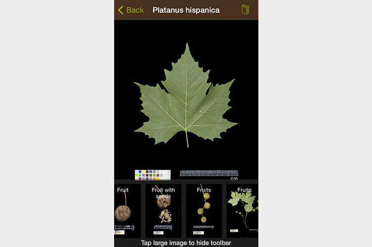
How long have we all dreamed of an app that could provide us automatically with reliable plant id? Well, Leafsnap UK may not fully get there but it is already a huge step ahead. Leafsnap UK uses visual recognition software to identify tree species from photos of their leaves. Its leaf recognition technology (think of face recognition but for trees) was developed by the US Leafsnap teams at Columbia University, University of Maryland and the Smithsonian Institution. The Natural History Museum in London and the botanists working at the Angela Marmont Centre for UK Biodiversity ensured the accurate adaptation of British tree species.
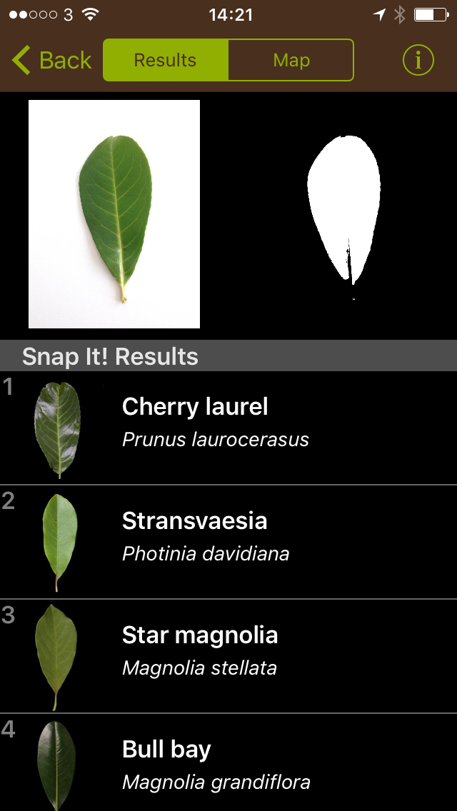
In order to identify a tree, you first have to photograph a leaf on a white background. Then, Leafsnap will suggest tree species with similar leafs to you. Now confirm the tree’s identity by checking the suggested images and text for matches. In a quick test in Weston Bank Park in Sheffield (UK), I still had to choose between 25 different species. However, that was already much quicker than other plant id apps, which are basically electronic versions of plant id books and where you have to go through the whole id process manually. An Android version is planned at the time of this post.
Leafsnap is available for free, but currently for iOS only in the AppStore
leafsnap-platanus-hispanicus-screenshot-on-grey-753x500
leafsnap-platanus-hispanicus-bark-on-grey-753x500

LVIZ author Philip Paar shakes the 3D tree

Philip Paar has been recognized as a geo design, Grassroots GIS, and landscape visualization enthusiast. In 2010, he started an ongoing affair with the digital content creation industry. Autodesk 3ds Max® users of this Blog are invited to check out the Laubwerk Plants Kits Freebie for free trial at laubwerk.com.

Laubwerk Plants Kits in 3ds Max

Large-Scale Multi-View 3D Reconstruction from Google Street-View Images

Get ready to be a part of the 3D map wars. While Google and Apple battle it out in creating complete 3D fully-textured models with their arsenal of impressive technological gadgetry, we could take part in our own personal skirmishes in generating 3D models of our own cities. Using sequential feature matching of images from street-view, generate 3D models through open-source image-based visualisation techniques. 

Michal Jancosek and his team from CMPMVS, a multi-view reconstruction software, experiments with large scale multi-view 3D reconstruction from Google Street-View Images. Fully automatic 3D reconstruction from 2424 600×800 images. Click here to view the video and go to http://ptak.felk.cvut.cz/sfmservice/ for more information.

Trimble will buy Sketchup from Google

Now, that took me by surprise: On April 26th, Google announced that it will sell Sketchup to Trimble. In a statement on the Google SketchUp blog, SketchUp Product Manager John Bacus promises that they will further provide a free version of Sketchup and that it will appeal to various target groups while focusing on architecture, engineering and construction industries. However, an immediate implication is the transfer of licenses and personal data to Trimble including non-geolocated (!) 3D models in the Google Warehouse (geo-located models submitted before the closing date belong with Google but Trimble gets a license to use them in the future). I am not a lawyer but it shows how quickly data could change owners these times… Today, the 3D warehouse models we constructed were owned by Google, tomorrow they will be owned by Trimble (who develops, unlike Google, military systems as well).

Other than that, I tend to be slightly optimistic that Sketchup will keep being one of my favorite tools as Trimble has a good reputation in GPS and surveying. I still remember my undergraduate studies where we already used Trimble equipment… Lately, Trimble seems to diversify and has shown an enormous appetite for buying various companies specialized in aerial data collection, CAD and GIS software, mobile systems, laser scanning, photogrammetry, and even UAV and RFID technology. Well, I hope that Trimble will further professionalize SketchUp without loosing its amazing intuition that revolutionized 3D modeling.


Future Internet, Special Issue Landscape

The Open Access journal Future Internet  has just published interesting papers from LVIZ authors Olaf Schroth et al. and Philip Paar (with Jörg Rekittke):

Tool or Toy? Virtual Globes in Landscape Planning

Low-Cost Mapping and Publishing Methods for Landscape Architectural Analysis and Design in Slum-Upgrading Projects

Open Data for Berlin

The idea of Open Data is not new and scientists have promoted free exchange of data for a long time. However, the term Open Data refers to the recent trend in informatics and geospatial sciences to provide geographic data free to use. Pioneers were particularly in the UK, US and Canada, where it has traditionally been claim that government geodata should be free. Vancouver for example launched a rather decent Open Data website. This initiative created many possibilities for various new location based apps such as the very successful Vantrash that gives inhabitants of Vancouver the current schedule for recycling and garbage pick-up.

Now, Berlin as first major German city has set up a website with government Open Data under http://daten.berlin.de/datensaetze and it is to hope that this will trigger similarly successful geospatial applications.

Urban Network Analysis Toolbox for ArcGIS 10

The City Form Research Group at MIT has released a state-of-the-art toolbox for urban network analysis. It comes as ArcGIS 10 toolbox and can be used to compute five types of graph analysis measures on spatial networks: Reach; Gravity; Betweenness; Closeness; and Straightness. Due to a very tight time schedule this month, I had no time to test it yet but the Youtube video looks very promising and I would appreciate any reports from users.

Direct download link

Plant Modeling at Siggraph 2011

Presenting my own poster “Model-based Visualization of Future Forest Landscapes” on the use of Biosphere3D in the Kimberley project at CALP, I got in touch with other researchers in the field. LIAMA, the Sino-French Lab of Computer Science, Automation and Applied Mathematics in Bejing, presented a poster on GreenLab. GreenLab is a program for the stochastic, functional and interactive modeling of plant growth that also considers different growth conditions. According to Prof. Kang, the development of GreenLab goes back to AMAP and Philippe de Reffye, one of the AMAP developers, who is also guest researcher at LIAMA and contributed to the development of GreenLab. The libraries of GreenLab will also contain more Asian species which are still rare in 3D. With its potential for functional modeling, Greenlab may become another promising plant modeler.

Later in the day, I visited the Speedtree booth. Speedtree clearly aims at Game Developers and Movie Makers; therefore it does not need to integrate botanical rules but it has to provide artistic control and “directability”. Furthermore, performance and different LODs are important for game developers and in gaming, SpeeTree is the current state-of-the-art. For landscape architects, it may be over the top with the basic version of SpeedTree Studio selling for $850 while the professional version, including a world construction set, can cost more than $12k.

Siggraph 2011 – Day 3

One of todays` highlights at SIGGRAPH 2011 in Vancouver was the approach of Prof. Deussen`s group in Konstanz and their partners at the universities in Shenzhen and Tel Aviv to use so-called “texture-lobes” for tree modelling from Lidar data. For more information, see http://graphics.uni-konstanz.de/publikationen/2011/texturelobesfortreemodeling/website/

Texture-Lobes for Tree Modelling from Soeren Pirk on Vimeo.

The afternoon was dedicated to urban modeling, starting with a review of the latest literature by Peter Wonka (Arizona State University) and Daniel Aliaga (Purdue University). During the second part of the session, Pascal Mueller from Procedural/ESRI (CityEngine) presented issues encountered in practice and their new Urban Vision project together with the urban planning department of San Francisco and Urban Sim (Paul Waddell). The session closed with a visually very engaging case study by Michael Frederickson from Pixar, using CityEngine for virtual London in Cars 2.

Google Mapping Technology for Nonprofits

What: Google Mapping Technology for Nonprofits

When: September 26-28, 2011, 8:30am – 5:00pm

Where: Morris J Wosk Centre for Public Dialogue at Simon Fraser University, Vancouver, British Columbia

Who should attend?: This workshop is intended for Canadian nonprofit technology specialists.

More information: http://vancouver.earthoutreach.org/home