Get ready to be a part of the 3D map wars. While Google and Apple battle it out in creating complete 3D fully-textured models with their arsenal of impressive technological gadgetry, we could take part in our own personal skirmishes in generating 3D models of our own cities. Using sequential feature matching of images from street-view, generate 3D models through open-source image-based visualisation techniques.
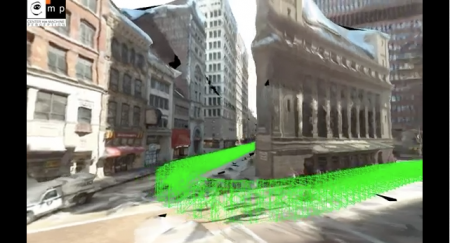
Michal Jancosek and his team from CMPMVS, a multi-view reconstruction software, experiments with large scale multi-view 3D reconstruction from Google Street-View Images. Fully automatic 3D reconstruction from 2424 600×800 images. Click here to view the video and go to http://ptak.felk.cvut.cz/sfmservice/ for more information.
Woah this specific blog site is excellent i adore researching your articles. Be up the very good artwork! You already know, loads of persons are shopping round with this data, you can help them to tremendously.
I was curious if you ever considered changing the page layout of your
site? Its very well written; I love what youve got to say.
But maybe you could a little more in the way of content so people could connect with
it better. Youve got an awful lot of text for only having one or 2 images.
Maybe you could space it out better?